Introduction
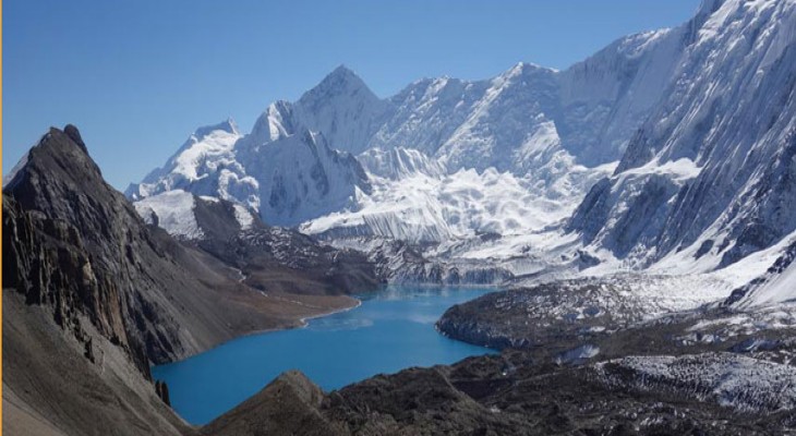
Tilicho Lake trekking is the off-the-beaten treeking in nepal and Tilicho Lake is known as the world highest lakes trekking (4919m). The lake is situated at a stunning location in the Annapurna region at an altitude of 5000m. Tilicho Lake trekking is a combination of Tilicho lake with the popular Annapurna Circuit trek.
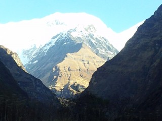
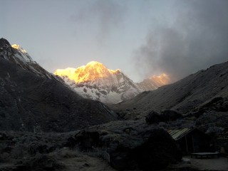
The Manang village is the tourist hub for the Annapurna circuit and Tilicho Lake trek. The Manang valley is inhabitant of Manangi people, who are influenced by Tibetan religion. Manang valley of Annapurna region is famous for the hospitality of local people and breathtaking spectacular panoramic view of the Himalaya ranges including deepest gorge of the world formed between the Annapurna I and the Dhaulagiri. Similarly, the dramatic view of Tilicho Peak, Nilgiri, Machhapuchhre, and Manaslu can also be seen along the trail. The rugged and picturesque trails show you crystal-clear Tilicho Lake, wild flowers, terraced rice fields and close and superb giant Himalayan panorama.
Since this is a strenuous trek, a good level of fitness is required to achieve the trek.
The best time to do this trek is around March to May and September to December.
Outline Itinerary
Day 1 Drive from Kathmandu to Ngadi via Besisahar, takes about eight hours.
Day 2 Trek from Ngadi (930m) to Chamje (1410m.) takes about six hours.
Day 3 Trek from Chamje (1410m.) to Dharapani (1960m.) takes about six hours.
Day 4 Trek from Dharapani to Chame (2675m.) takes about five and half hours.
Day 5 Trek from Chame to Pisang (3100m.) takes about five hours.
Day 6 Trek from Pisang to Manang (3440m.) takes about five and half hours.
Day 7 Rest day at Manang and hang in and around town.
Day 8 Trek from Manang to Khangsar which takes approximately five hours.
Day 9 Trek from Khangsar to Tilicho Lake and it takes about six hours.
Day 10 Trek from Tilicho Lake to Mesokanto Pass (5315m.) and it takes about seven hours.
Day 11 Trek from Mesokanto Pass to Jomsom (2741 m.) via Thimi (2760 m.) which takes about six hours.
Day 12 Fly from Jomsom to Pokhara takes about 35 minutes.
Day 13 Drive from Pokhara to Kathmandu takes about seven hours.
Day 14 Final departure
Day 1 : Drive from Kathmandu to Ngadi via Besisahar, takes about eight hours.
After early-morning breakfast, our guide will pick you up from the hotel and take you to the bus station. Drive from Kathmandu to Ngadi via Besisahar, takes about eight hours. Stay overnight at lodge in Ngadi.
Accomodation :
Day 2 : Trek from Ngadi (930m) to Chamje (1410m.) takes about six hours.
Trek from Ngadi (930m) to Chamje (1410m.) takes about six hours. Ahead the Marshyangdi valley forms a steep V-shape and you follow the winding mountain path down through Syange (1100m.) where there is a beautiful waterfall above it and along the river for some distance. The trail then climbs steeply and the path is cut into the sheer cliff-face some 200-300m above the riverbed.. Now the trail begins to observe small ups and downs to Chamje through the forests. Stay overnight at lodge.
Accomodation :
Day 3 : Trek from Chamje (1410m.) to Dharapani (1960m.) takes about six hours.
Trek from Chamje (1410m.) to Dharapani (1960m.) takes about six hours. The first part of the trail descends to the river and after crossing a suspension bridge, you begin a climb to Sattale (1550m.) on a path so steep that it seems one slip would send you hurtling down into the valley. You continue on an undulating path above the river. Climbing the zigzag path to the top of the hill, we see the level, plain of Tal (1700m.) before us. You descend to a grassy riverbank that leads to Tal with its hotels and teahouses. Here you can enjoy the exhilarating waterfalls .Beyond Tal, the valley narrows and the path becomes high and winding and in several areas hewn from the rock itself. Beyond the small village of Karte (1900m.), there is a bit more cliff-walking before the path drops again to the river. You cross a suspension bridge and climb the short distance to the stone Mani marking the entrance to Dharapani (1960m.), and our camp for the night. Stay overnight at lodge.
Accomodation :
Day 4 : Trek from Dharapani to Chame (2675m.) takes about five and half hours.
Trek from Dharapani to Chame (2675m.) takes about five and half hours. As you cut through a narrow field from the village, the Dudh Khola, originates from the south face of Manaslu, enters on the opposite bank. The Marshyangdi then veers to the left and as Annapurna II becomes visible ahead, you arrive at Bagarchhap, a Bhote village with prayer flags fluttering in the breeze around Buddhist monastery. Continuing to climb through forests of pine and oak, you pass through Danaque (2210m.). The trail goes through flat level until you reach Chame where there are government offices, shops and hotels. Chame is the administrative headquarters for the Manang district. Stay overnight at lodge.
Accomodation :
Day 5 : Trek from Chame to Pisang (3100m.) takes about five hours.
Trek from Chame to Pisang (3100m.) takes about five hours. With Lamjung Himal (6893m) sparkling in the morning sun, you set off for Pisang. The mountain disappears as you climb the path up the valley, passing a huge apple orchard. You continue through a fir and pine forest, climbing to a high, rocky area as the opposite bank becomes an impassable cliff. From this point the valley becomes extremely steep-sided as you follow the path to Bhratang (2950m.). You now walk through a pine forest and as the forest ends, the valley changes from a V-shape to a gentle U-shape, opening up a wonderful vista before us. You can see the east peak of Annapurna II as well as Pisang Peak (6091m.) to the north-east. Continuing on, you come to a long Mani wall by a bridge and the lower village of Pisang. Stay overnight at lodge.
Accomodation :
Day 6 : Trek from Pisang to Manang (3440m.) takes about five and half hours.
Trek from Pisang to Manang (3440m.) takes about five and half hours. Beyond Pisang, the trail climbs a steep ridge that affords good views of the Manang valley and Tilicho peak (7145m.). Descending past Manang's airstrip at Hungde (3320m.), you come to a level area from where the north-east face of Annapurna III rises majestically above you. From the wide plains of the Sabje Khola Valley, Annapurna IV (7525m.) also becomes visible. Just beyond this point you cross the considerably reduced flow of the Marshyangdi Khola via a wooden bridge to the tiny village of Mungji. Large Chortens and Mani walls abound and the tall peaks of the Himalaya spread out before us - Annapurna II, Annapurna III, Annapurna IV, Gangapurna (7455m.) and to the rear, Tilicho Peak (7145m.). After a short steep climb you reach Manang. Stay overnight at lodge.
Accomodation :
Day 7 : Rest day at Manang and hang in and around town.
Rest day at Manang and hang in and around town. This is an important rest and acclimatization day today before crossing the Thorung La. There are optional day walks such as crossing the river to see the tremendous icefall coming down from the Annapurna, or climbing high above the village for a full panorama of the Annapurna range and the Manang Valley. Stay overnight at lodge.
Accomodation :
Day 8 : Trek from Manang to Khangsar which takes approximately five hours.
Trek from Manang to Khangsar which takes approximately five hours. The path is gradual descent and you cross a suspension bridge over Jharsing Khola (stream). You trek through dry land though you can see shrubs on the both sides. The panoramic views of Annapurna range completely mesmerize you. Khangsar is a Gurung village. There you find a small monastery, chorten, mani walls and prayer flags.
Accomodation :
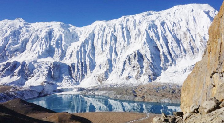
Day 9 : Trek from Khangsar to Tilicho Lake and it takes about six hours.
Trek from Khangsar to Tilicho Lake and it takes about six hours. This day you trek gradual up until you reach destination. The path is quite covered by small crystals and shrubs can be seen on both sides. Somewhere in trekking you cross few streams. Tilicho Lake is situated at the highes. From here you can enjoy the closer and panoramic views of Tilicho Mountain and many others.
Accomodation :
Day 10 : Trek from Tilicho Lake to Mesokanto Pass (5315m.) and it takes about seven hours.
Trek from Tilicho Lake to Mesokanto Pass (5315m.) and it takes about seven hours. The path is full of ups and down until you reach Mesokanto Pass. The trail is quite narrow and you trek over icy path. The panoramic views of Annapurna range, Tilicho, Dhaulagiri along with more than ten mountains completely mesmerize you.
Accomodation :
Day 11 : Trek from Mesokanto Pass to Jomsom (2741 m.) via Thimi (2760 m.) which takes about six hours.
Trek from Mesokanto Pass to Jomsom (2741 m.) via Thimi (2760 m.) which takes about six hours. From Mesokanto Pass, the trail goes steep down to Jomsom. This day you trek through pine forest. Before you reach Jomsom, you cross Thimi inhabited by mostly Buddhists. There are not tea houses available from en route from Tilicho Lake to Jomsom.
Accomodation :
Day 12 : Fly from Jomsom to Pokhara takes about 35 minutes.
Fly from Jomsom to Pokhara takes about 35 minutes. The flights are available during the morning time. The strong breeze blows during and after and frequent change of the weather prevents the flight being landed and taken off in the afternoon. Stay overnight at hotel in Pokhara.
Accomodation :
Day 13 : Drive from Pokhara to Kathmandu takes about seven hours.
Drive from Pokhara to Kathmandu takes about seven hours. While driving from Pokhara to Kathmandu, you head up to Damauli,, Dumre, Muglin and Kurintar where Nepal's first Cable car is operated to reach to Manakamana Temple. En route, you could enjoy the mountain views, green sceneries, rice terrace fields, vegetable fields and people being engaged in their daily life activities. From Naubishe you climb up to Thankot, the gateway to capital city, Kathmadu.
Accomodation :
Day 14 : Final departure
Your adventure in Nepal comes to an end today! There is nothing to do but trade emails with your travel companions and organize your photos. A representative from J.vill nepal Trekking will take you to the airport, approximately 3 hours before your scheduled flight. On your way home you'll have plenty of time to plan your next adventure in the wonderful country of Nepal.
Accomodation :
Features Included on Tilicho Lake Trek
Features Not Included on Tilicho Lake Trek
Things To know
Requirement
This list is a guideline to help you pack for your adventure. Also understand that the items listed below will vary a little according to the season and the trek duration. Those items marked by an asterisk (*) are provided by Himalayan Glacier inclusive in the service. The weight limit for your luggage is 33 pounds or 15 kg. Remember that your luggage will be carried by your porter but you are required to carry a day-pack (with your valuables or anything important) on your own. We also suggest that you pack only what is necessary.
Important documents and items
- Valid passport, 2 extra passport size photos, airline tickets
- Separate photocopies of passport, visa form (easily obtained at Kathmandu airport), proof of insurance
- Dollars, pounds or Euros in cash for purchasing Nepalese visa at Kathmandu airport, for paying for restaurants and hotels, for gratuities, snacks, and to purchase your own drinks and gifts
- Credit cards, Bank/ATM/Cash machine cards for withdrawing funds from cash machines (bring a photocopy of your cards), traveler's checks, etc.
Head
- Bandana or head scarf, also useful for dusty conditions
- Warm hat that covers your ears (wool or synthetic)
- Headlamp with extra batteries and bulbs
- Sunglasses with UV protection
- Prescription sunglasses (if required)
Upper Body
- Polypropylene shirts (1 half sleeve and 2 long sleeves)
- Light and expedition weight thermal tops
- Fleece wind-stopper jacket or pullover
- Waterproof (preferably breathable fabric) shell jacket
- Down vest and/or jacket *
- Gore-Tex jacket with hood, waterproof and breathable
Hands
- 1 pair of lightweight poly-liner gloves.
- 1 pair of lightweight wool or fleece gloves
- 1 pair of mittens, consists of 1 Gore-Tex over mitt matched with a very warm polar-fleece mitt liner (seasonal)
Lower Body
- Non-cotton underwear briefs
- 1 pair of Hiking shorts
- 1 pair of Hiking trousers
- 1 pair of lightweight thermal bottoms (seasonal)
- 1 pair of fleece or woolen trousers
- 1 pair of waterproof shell pants, breathable fabric
Feet
- 2 pairs of thin, lightweight inner socks
- 2 pairs of heavy poly or wool socks
- 1 pair of Hiking boots with spare laces (sturdy soles, water resistant, ankle support, “broken in”)
- 1 pair of trainers or running shoes and/or sandals
- Cotton socks (optional)
- Gaiters (winter only), optional, “low” ankle high version
Sleeping
- 1 sleeping bag (good to -10 degrees C or 14 degrees F)*
- Fleece sleeping bag liner (optional)
Rucksack and Travel Bags
- 1 medium rucksack (50-70 liters/3000-4500 cubic inches, can be used for an airplane carryon)
- 1 large duffel bag *
- A small daypack/backpack for carrying your valuables, should have good shoulder padding
- Small padlocks for duffel-kit bags
- 2 large waterproof rucksack covers (optional)
Medical
- Small, personal first-aid kit. (simple and light)
- Aspirin, first-aid tape, and plasters (Band-Aids)
- 1 skin-blister repair kit
- Anti-diarrhea pills
- Anti-headache pills
- Cough and/or cold medicine
- Anti-altitude sickness pills: Diamox or Acetylzolamide
- Stomach antibiotic: Ciprofloxacin, etc. Do not bring sleeping pills as they are a respiratory depressant.
- Water purification tablets or water filter
- 1 set of earplugs
- Extra pair of prescription glasses, contact lens supplies
Practical Items
- 1 small roll of repair tape, 1 sewing-repair kit
- 1 cigarette lighter, 1 small box of matches
- 1 compass or GPS(optional)
- 1 alarm clock/watch
- 1 digital camera with extra cards and batteries
- large Ziplocs
- 2 water bottles (1 liter each)
- 1 small folding knife
- Binoculars (optional)
- 4 large, waterproof, disposable rubbish sacks
Toiletries
- 1 medium-sized quick drying towel
- Toothbrush/paste (preferably biodegradable)
- Multi-purpose soap (preferably biodegradable)
- Deodorants
- Nail clippers
- Face and body moisturizer
- Female hygiene products
- Small mirror
Personal Hygiene
- Wet wipes (baby wipes)
- Tissue /toilet roll
- Anti-bacterial hand wash