Introduction
Tsum Valley – Manslu Circuit Trek is located in the northernmost part of Gorkha district. Since the trekking trail falls under ‘controlled’ region, trekkers will be required to obtain special trekking permit to enter the area.
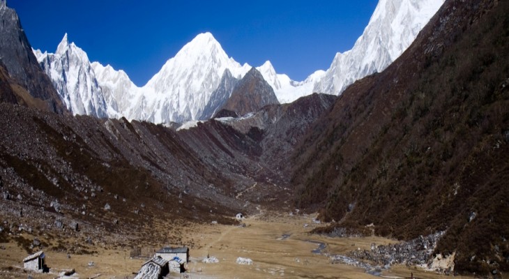
Tsum Valley is popularly known as the ‘hidden valley’, owing to its remoteness and years of isolation from the outside world. In Tibetan dialect ‘Tsum’ literally means ‘lively’ and the inhabitants are called Tsumba people. The locals are devout Buddhists and follow the teachings of Guru Rinpoche. Tsum valley continues to preserve its ancient Buddhist culture and natural treasures of streams and rivers, towering mountains, cascading waterfalls, and mountain hot springs. The unique and peculiar culture, custom and lifestyle of local Tsumba people, who closely resembles their neighbor Tibetans, are a major attraction. Tsum Valley is also considered a home to the legendary and elusive Yetis.
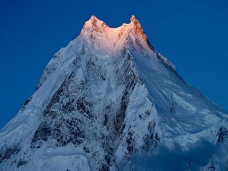
Manaslu trek on the other hand is one of the toughest and most rewarding trekking trails under the shadow of Mt. Manaslu (8156m), the eight highest mountain in the world. Trekking in Manaslu will involve crossing several high Himalayan passes including Larkya La pass (5213m). Along the trek, you will have crystal clear views of Manaslu Himal, Baudha Himal, Ganesh Himal and Sringi Himal ranges.
Although Tsum Valley and Mansalu can be approached as independent trekking trails, we have combined the two beautiful routes to offer you the richest experience of the Himalayas, local culture and nature. Our first leg of the trek covers the Tsum Valley before finally joining the regular route of Manaslu Trek.
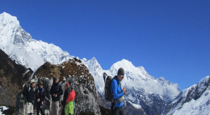
The trek will be a mix of camping and lodge, however home-stay facilities are also available at different points along the trail. The lodges are of very basic standards, but serve locally sourced hygienic dishes.
J.vill nepal trekking offers both regular packages and customized trekking itineraries depending upon your interest, time schedule and budget. Our experience and professional trekking guides and support assistants will ensure that you have a trekking experience worth a lifetime.
Outline Itinerary
Day 1 Drive from Kathmandu to Arughat Bazaar (570m.) takes about six and half hours.
Day 2 Trek from Arughat Bazaar passing through Soti Khola (730m.) to Soti Khola or Liding (800m) takes about six hours.
Day 3 Trek from Liding thru Machha Khola to Khorlabeshi (930m.) takes about six hours.
Day 4 Trek from Khorlabeshi to Jagat (1440m.) takes about six hours.
Day 5 Trek from Jagat to Lokpa/Lukuwa (2240m.) takes about six hours.
Day 6 Trek from Lokpa to Rainjam (2600m.) takes six hours.
Day 7 Trek from Rainjam thru Chhokangparo (3010m.) to Rachen Bompa (3300m) takes five hours.
Day 8 Trek from Rachen Bompa thru Nile (3361m.) to Mu Gompa (3700m) takes five hours.
Day 9 Rest day in Mu Gompa.
Day 10 Trek from Mu Gumpa to Chekya (4240m.) takes 7 hours.
Day 11 Trek from Chekya thru Dhaldang (Dangchet) to Yamdro (4500m) takes 6 - 7 hours.
Day 12 Trek from Yamdro to Bhajyo (4330m), descending the whole way, takes 3 hours.
Day 13 Trek from Bhajyo to Chhule (3347m) takes 6 hours on an entirely descending path.
Day 14 Trek from Chhule to Rainjam (2600m.) takes 5 hours.
Day 15 Trek from Rachen Gomba to Tumje (3200m.). Stay overnight in camp.
Day 16 Trek from Tumje to Bihi (2130m.). Stay overnight in camp.
Day 17 Trek from Bihi to Namrung (2900m.) takes about five hours.
Day 18 Trek from Namrung to Lhogaon (3100m.) takes about four hours.
Day 19 Trek from Lhogaon to Samagaon (3390m.) takes about four hours.
Day 20 This is a day for rest at Samagaon to give you some acclimatization.
Day 21 Trek from Samagaon to Samdo (3690m.) takes about four hours.
Day 22 Trek from Samdo to Larkya La Phedi (4460m.) takes about three hours.
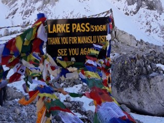
Day 23 Trek from Larkya La Phedi to Larkya La (Pass) (5135m.) to Bimthang (3590 m.) takes about seven hours.
Day 24 Trek from Bimthang to Dharapani (1860m.) takes about four hours.
Day 25 Trek from Dharapani to Jagat (1800m) takes about six hours.
Day 26 Trek from Jagat to Nagdi (850m.) takes about four hours.
Day 27 Drive Nagdi to Kathmandu
Day 28 Final departure
Day 1 : Drive from Kathmandu to Arughat Bazaar (570m.) takes about six and half hours.
You drive along the Kathmandu-Pokhara Highway for the first part of the day then drive towards to Arughat Bazaar. Stay overnight in camp.
Accomodation :
Day 2 : Trek from Arughat Bazaar passing through Soti Khola (730m.) to Soti Khola or Liding (800m) takes about six hours.
You trek over a flat leveled path along the bank of Budhi Gandaki River through mostly terraces, numerous villages, green hills, some pretty waterfalls and green forest. To reach Liding, the trail fluctuates uphill and downhill through forest of Sal, Chilaune and other local vegetation. Liding is a village at the bank of the Budhi Gandaki. Stay overnight in camp or simple teahouse.Accomodation :
Day 3 : Trek from Liding thru Machha Khola to Khorlabeshi (930m.) takes about six hours.
The zigzag path passes through forest, villages, streams, pretty waterfalls and green valley until you reach Lapu Besi. This is a village mainly covered by Mongolian inhabitants. Now you again traverse the zigzag path to reach Machha Khola and on to Khorlabeshi. There is a small market with a few shops and lodges. Stay overnight in camp or simple teahouse.Accomodation :
Day 4 : Trek from Khorlabeshi to Jagat (1440m.) takes about six hours.
You cross the Machha Khola (Fish Stream) and head upstream to the tiny village of Khola Bensi and the hot springs at Tatopani. The trail is quite exposed and challenging in places. After a short section of forest path you reach the single teahouse at Doban. At Lauri, you cross the river on a suspension bridge, and then climb on a high path to the fields of Jagat, where you camp. Stay overnight in camp.Accomodation :
Day 5 : Trek from Jagat to Lokpa/Lukuwa (2240m.) takes about six hours.
The early part of trek moves gently uphill and then follows a flat leveled path. You cross a suspension bridge over Budhi Gandaki before you enter Philim. Philim is a big village mainly inhabited by the Gurungs. Form Philim you climb a gradual up hill stopping for lunch at Ekle Bhatti. Lokpa is the first village as you enter the Tsum valley. Stay overnight in camp.Accomodation :
Day 6 : Trek from Lokpa to Rainjam (2600m.) takes six hours.
You take an ascending route to reach Chumling stopping for lunch along the way. Chumling is located on the south face of the Shingri Himal. This day you enjoy a pleasant visit to the Gombas of Chumling. This day is challenging as it is an ascending path the entire way. Stay overnight in camp in Rainjam.Accomodation :
Day 7 : Trek from Rainjam thru Chhokangparo (3010m.) to Rachen Bompa (3300m) takes five hours.
This is a tough and long day of walking but the scenic views of the valley amply compensates for the long walk. Chhokangparo is situated on the flat land and consists of 2 settlements, Chhokang and Paro. From here you can view the Ganesh Himal range. Some households practice polyandry. This area is prominent for it's Tibetan Buddhist heritage. Stay overnight in camp in Rachen Bompa.Accomodation :
Day 8 : Trek from Rachen Bompa thru Nile (3361m.) to Mu Gompa (3700m) takes five hours.
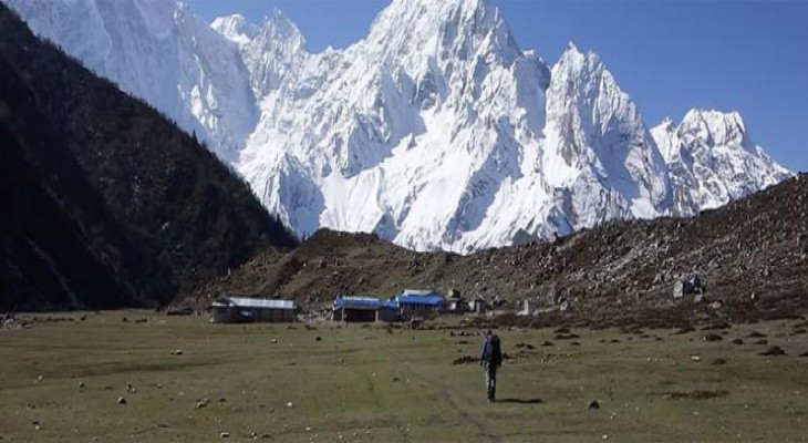
Nile is the last village heading north in the upper Tsum valley. This village is situated on the banks of the Shiar Khola and is consists of large number of households. Mu Gompa is home to a very old monastery and there are no village establishments here. It is located at the highest and farthest point in the Tsum valley. This trail is used to import and export things to and from Tibet. You may come across several yak trains supplying goods to local villages. Stay overnight in camp.Accomodation :
Day 9 : Rest day in Mu Gompa.
Today we can take excursions to the many snow covered peaks in the area for the most spectacular views on the trek. Stay overnight in camp.Accomodation :
Day 10 : Trek from Mu Gumpa to Chekya (4240m.) takes 7 hours.
This day presents you a long and challenging walk. Stay overnight in camp.Accomodation :
Day 11 : Trek from Chekya thru Dhaldang (Dangchet) to Yamdro (4500m) takes 6 - 7 hours.
The trail ascends all the way to Yamdro. Stay overnight in camp.Accomodation :
Day 12 : Trek from Yamdro to Bhajyo (4330m), descending the whole way, takes 3 hours.
Bhajyo is the last village before entering Tibet. It contains approximately 22 houses and a few yak farms. Stay overnight in camp.Accomodation :
Day 13 : Trek from Bhajyo to Chhule (3347m) takes 6 hours on an entirely descending path.
This day you can enjoy the glimpses of the Punchen Himal. Stay overnight in camp.Accomodation :
Day 14 : Trek from Chhule to Rainjam (2600m.) takes 5 hours.
This day you continue your descent by retracing the path from your ascent. Stay overnight in camp.Accomodation :
Day 15 : Trek from Rachen Gomba to Tumje (3200m.). Stay overnight in camp.
Accomodation :
Day 16 : Trek from Tumje to Bihi (2130m.). Stay overnight in camp.
Accomodation :
Day 17 : Trek from Bihi to Namrung (2900m.) takes about five hours.
In the beginning, you trek almost a flat leveled path and then the trail moves uphill all the way to Namrung through forest. From here, you can enjoy the spectacular views of Mt. Manaslu, rock hills, a green valley and ridges. Namrung is a Buddhist village where there are monasteries, a water turbine, hydro electricity power house, Mani walls, chortens and prayer flags can be seen fluttering in the sky. The typical houses remind you of Tibetan architecture. Stay overnight in camp.Accomodation :
Day 18 : Trek from Namrung to Lhogaon (3100m.) takes about four hours.
You trek over a winding path moves through the inner Himalayan range. On the way, you can enjoy mountain views of Rupinala pass, Mt. Manaslu, Gorkha Himal, Dwijen Himal, Saula Himal, Lajing peak, and many other snow capped mountains and peaks. As you go up the vegetation decreases. You come across mani walls, chortens, prayer flags and monasteries. Before you reach Lho Gaon, you pass a Tibetan village and Lihi Gaon. You can catch panoramic views of Mt. Manaslu, Gorkha Himal, Dwijen Himal, Saula Himal, Lajing peak and others from Lho Gaon. Stay overnight in camp.Accomodation :
Day 19 : Trek from Lhogaon to Samagaon (3390m.) takes about four hours.
You follow the right bank of the river, with views of Peak 29 ahead. As you continue on the main trail you soon reach the fields of Sama Gaon, 3500m. You camp at Sama Gompa, 20 minutes beyond the village near the Tibetan border. Stay overnight in camp.Accomodation :
Day 20 : This is a day for rest at Samagaon to give you some acclimatization.
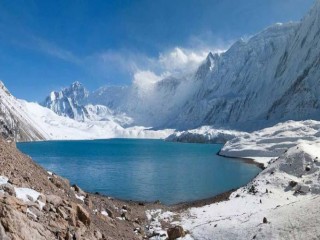
You can hike to Manaslu Base Camp for excellent views of Samdo (Pang phuchuli); Nagdi chuli, Simnang Himal, Manaslu glacier, Manaslu ice fall and you can see Birendra Kunda is an ice lake nearby the Manaslu Base Camp. Stay overnight in camp.Accomodation :
Day 21 : Trek from Samagaon to Samdo (3690m.) takes about four hours.
You trek gently uphill all the way to Samdo through a desert path and windy valley. The Tibetan border is just four kilometers away from Samdo. But visitors are not allowed to pass the border. This is an excellent view point for Mt. Manaslu, Samdo (Pang phuchuli), Nagdi chuli, Simnang Himal, Manaslu glacier, Manaslu ice fall and several other majestic peaks. Stay overnight in camp.Accomodation :
Day 22 : Trek from Samdo to Larkya La Phedi (4460m.) takes about three hours.
The trail is rocky and zigzags all the way to your destination. Before you reach Larka La Phedi, there is a market called Larkya Bazaar (market) where seasonal fairs are held for the local folks. People bring goods from Tibet to sell it here. You will also find a Dharmasala at Larkya La Phedi. Stay overnight in camp.Accomodation :
Day 23 : Trek from Larkya La Phedi to Larkya La (Pass) (5135m.) to Bimthang (3590 m.) takes about seven hours.
Early in the morning you begin to trek a steep ascent until Larkya La through a rocky and windy path. From here, you can enjoy the views of Larkya peak, Mt. Manaslu, Ratna chuli, Cheo Himal and many other snow capped mountains and peaks. Crossing this pass, you follow a steep downhill path through rock and ice. On the way, you will encounter many icy lakes. Bimthang is a broad and level ablation valley with a number of Mani walls and deserted houses. Stay overnight in camp.Accomodation :
Day 24 : Trek from Bimthang to Dharapani (1860m.) takes about four hours.
Crossing this high pasture you descend the valley of the Burdin Khola to the area of the Base Camp for the West side of Manaslu. From a ridge at 4150 meters, you have excellent views of Manaslu to the South East and Annapurna II to the South West. Beyond a bridge over the headwaters of the Dudh Khola, you descend into a rhododendron forest and follow a trail through a narrow valley until you reach the highest cultivated land in this valley at Karche, 2785 meters. Walking down you cross a stream to reach Tilje. Leaving Tilje, you trek uphill for nearly 45 minutes and reach Dharapani crossing a bridge over the Marshyangdi River. Stay overnight in camp.Accomodation :
Day 25 : Trek from Dharapani to Jagat (1800m) takes about six hours.
You trek all the way over a descended path along the bank of Dudh Khola (river) and Marshyangdi River. On the way, you walk through pleasant villages such as Taal is an attractive village with a pretty waterfall and you can enjoy the sight of lush green hills. Eventually, you come across Jagat is a stone village situated on a shelf, that juts into the precipitous Marsyangdi valley. Stay overnight in camp.Accomodation :
Day 26 : Trek from Jagat to Nagdi (850m.) takes about four hours.
A steep trail descends from Jagat through Marshyangdi valley. You cross Marshyangdi River at Syange and walk through Ghermu Path (Ghermu field). This part of the trek is pleasant through a flat leveled path with views of green valleys and villages at some distance. Past this Ghermu field and a village, your trail goes uphill for nearly half an hour to reach Bahundanda. At this point, you descend all the way to Nagdi. Stay overnight in camp.Accomodation :
Day 27 : Drive Nagdi to Kathmandu
A steep trail descends from Jagat through Marshyangdi valley. You cross Marshyangdi River at Syange and walk through Ghermu Path (Ghermu field). This part of the trek is pleasant through a flat leveled path with views of green valleys and villages at some distance. Past this Ghermu field and a village, your trail goes uphill for nearly half an hour to reach Bahundanda. At this point, you descend all the way to Nagdi. On the same day drive from Nagdi to Kathmandu. It is a picturesque drive on the way back to Kathmandu along the banks of the Marshyangdi and Trishuli rivers with splendid views of green hills, mountains, farming terraces and colorful villages on both sides of road. A steep trail descends from Jagat through Marshyangdi valley. You cross Marshyangdi River at Syange and walk through Ghermu Path (Ghermu field). This part of the trek is pleasant through a flat leveled path with views of green valleys and villages at some distance. Past this Ghermu field and a village, your trail goes uphill for nearly half an hour to reach Bahundanda. At this point, you descend all the way to Nagdi. On the same day drive from Nagdi to Kathmandu. It is a picturesque drive on the way back to Kathmandu along the banks of the Marshyangdi and Trishuli rivers with splendid views of green hills, mountains, farming terraces and colorful villages on both sides of road. A steep trail descends from Jagat through Marshyangdi valley. You cross Marshyangdi River at Syange and walk through Ghermu Path (Ghermu field). This part of the trek is pleasant through a flat leveled path with views of green valleys and villages at some distance. Past this Ghermu field and a village, your trail goes uphill for nearly half an hour to reach Bahundanda. At this point, you descend all the way to Nagdi. On the same day drive from Nagdi to Kathmandu. It is a picturesque drive on the way back to Kathmandu along the banks of the Marshyangdi and Trishuli rivers with splendid views of green hills, mountains, farming terraces and colorful villages on both sides of road. A steep trail descends from Jagat through Marshyangdi valley. You cross Marshyangdi River at Syange and walk through Ghermu Path (Ghermu field). This part of the trek is pleasant through a flat leveled path with views of green valleys and villages at some distance. Past this Ghermu field and a village, your trail goes uphill for nearly half an hour to reach Bahundanda. At this point, you descend all the way to Nagdi. On the same day drive from Nagdi to Kathmandu. It is a picturesque drive on the way back to Kathmandu along the banks of the Marshyangdi and Trishuli rivers with splendid views of green hills, mountains, farming terraces and colorful villages on both sides of road. A steep trail descends from Jagat through Marshyangdi valley. You cross Marshyangdi River at Syange and walk through Ghermu Path (Ghermu field). This part of the trek is pleasant through a flat leveled path with views of green valleys and villages at some distance. Past this Ghermu field and a village, your trail goes uphill for nearly half an hour to reach Bahundanda. At this point, you descend all the way to Nagdi. On the same day drive from Nagdi to Kathmandu. It is a picturesque drive on the way back to Kathmandu along the banks of the Marshyangdi and Trishuli rivers with splendid views of green hills, mountains, farming terraces and colorful villages on both sides of road. A steep trail descends from Jagat through Marshyangdi valley. You cross Marshyangdi River at Syange and walk through Ghermu Path (Ghermu field). This part of the trek is pleasant through a flat leveled path with views of green valleys and villages at some distance. Past this Ghermu field and a village, your trail goes uphill for nearly half an hour to reach Bahundanda. At this point, you descend all the way to Nagdi. On the same day drive from Nagdi to Kathmandu. It is a picturesque drive on the way back to Kathmandu along the banks of the Marshyangdi and Trishuli rivers with splendid views of green hills, mountains, farming terraces and colorful villages on both sides of roaAccomodation :
Day 28 : Final departure
Your adventure in Nepal comes to an end today! There is nothing to do but trade emails with your travel companions and organize your photos. A representative fromJ.vill nepalTrekking will take you to the airport, approximately 3 hours before your scheduled flight. On your way home you'll have plenty of time to plan your next adventure in the wonderful country of Nepal.Accomodation :
Features Included on Tsum Valley - Manaslu Circuit Trek
Features Not Included on Tsum Valley - Manaslu Circuit Trek
Things To know
Requirement
Equipments & Packing List
This list is a guideline to help you pack for your adventure. Also understand that the items listed below will vary a little according to the season and the trek duration. Those items marked by an asterisk (*) are provided by Himalayan Glacier inclusive in the service. The weight limit for your luggage is 33 pounds or 15 kg. Remember that your luggage will be carried by your porter but you are required to carry a day-pack (with your valuables or anything important) on your own. We also suggest that you pack only what is necessary.
Important documents and items
- Valid passport, 2 extra passport size photos, airline tickets
- Separate photocopies of passport, visa form (easily obtained at Kathmandu airport), proof of insurance
- Dollars, pounds or Euros in cash for purchasing Nepalese visa at Kathmandu airport, for paying for restaurants and hotels, for gratuities, snacks, and to purchase your own drinks and gifts
- Credit cards, Bank/ATM/Cash machine cards for withdrawing funds from cash machines (bring a photocopy of your cards), traveler's checks, etc.
Head
- Bandana or head scarf, also useful for dusty conditions
- Warm hat that covers your ears (wool or synthetic)
- Headlamp with extra batteries and bulbs
- Sunglasses with UV protection
- Prescription sunglasses (if required)
Upper Body
- Polypropylene shirts (1 half sleeve and 2 long sleeves)
- Light and expedition weight thermal tops
- Fleece wind-stopper jacket or pullover
- Waterproof (preferably breathable fabric) shell jacket
- Down vest and/or jacket *
- Gore-Tex jacket with hood, waterproof and breathable
Hands
- 1 pair of lightweight poly-liner gloves.
- 1 pair of lightweight wool or fleece gloves
- 1 pair of mittens, consists of 1 Gore-Tex over mitt matched with a very warm polar-fleece mitt liner (seasonal)
Lower Body
- Non-cotton underwear briefs
- 1 pair of Hiking shorts
- 1 pair of Hiking trousers
- 1 pair of lightweight thermal bottoms (seasonal)
- 1 pair of fleece or woolen trousers
- 1 pair of waterproof shell pants, breathable fabric
Feet
- 2 pairs of thin, lightweight inner socks
- 2 pairs of heavy poly or wool socks
- 1 pair of Hiking boots with spare laces (sturdy soles, water resistant, ankle support, “broken in”)
- 1 pair of trainers or running shoes and/or sandals
- Cotton socks (optional)
- Gaiters (winter only), optional, “low” ankle high version
Sleeping
- 1 sleeping bag (good to -10 degrees C or 14 degrees F)*
- Fleece sleeping bag liner (optional)
Rucksack and Travel Bags
- 1 medium rucksack (50-70 liters/3000-4500 cubic inches, can be used for an airplane carryon)
- 1 large duffel bag *
- A small daypack/backpack for carrying your valuables, should have good shoulder padding
- Small padlocks for duffel-kit bags
- 2 large waterproof rucksack covers (optional)
Medical
- Small, personal first-aid kit. (simple and light)
- Aspirin, first-aid tape, and plasters (Band-Aids)
- 1 skin-blister repair kit
- Anti-diarrhea pills
- Anti-headache pills
- Cough and/or cold medicine
- Anti-altitude sickness pills: Diamox or Acetylzolamide
- Stomach antibiotic: Ciprofloxacin, etc. Do not bring sleeping pills as they are a respiratory depressant.
- Water purification tablets or water filter
- 1 set of earplugs
- Extra pair of prescription glasses, contact lens supplies
Practical Items
- 1 small roll of repair tape, 1 sewing-repair kit
- 1 cigarette lighter, 1 small box of matches
- 1 compass or GPS(optional)
- 1 alarm clock/watch
- 1 digital camera with extra cards and batteries
- large Ziplocs
- 2 water bottles (1 liter each)
- 1 small folding knife
- Binoculars (optional)
- 4 large, waterproof, disposable rubbish sacks
Toiletries
- 1 medium-sized quick drying towel
- Toothbrush/paste (preferably biodegradable)
- Multi-purpose soap (preferably biodegradable)
- Deodorants
- Nail clippers
- Face and body moisturizer
- Female hygiene products
- Small mirror
Personal Hygiene
- Wet wipes (baby wipes)
- Tissue /toilet roll
- Anti-bacterial hand wash